Summary

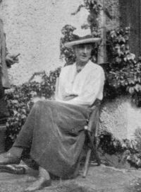
Portrait of Geraldine Edith Mitton Geraldine Edith Mitton Maps of Old London — John Rocque - London in 1741-45 (1908)

We have to go far before we clear the houses to the east. Stepney and Bethnal Green are fairly thickly populated, and though surrounded by open ground, are connected by houses all the way from the City. But in the bend of the river by Wapping the chief area is occupied by market-gardens. Crossing over to the other side, we find the market-gardens very prominent; as London grows larger she thrusts her sources of supply further from her.
Source: Wikisource

Portrait of Geraldine Edith Mitton Geraldine Edith Mitton Maps of Old London — John Rocque - London in 1741-45 (1908)

It is beyond Oxford Street northward that the difference is striking. This district was only just being built upon, and the well-laid-out streets soon run off into open country. "Marybone" Gardens, a favourite tea-garden, and the church, and a few houses, form a little hamlet just connected with the other part of London by a single street, and further westward, north of Berkeley Square, are fields.
Source: Wikisource

Portrait of Geraldine Edith Mitton Geraldine Edith Mitton Maps of Old London — John Rocque - London in 1741-45 (1908)

George's, was a busy High Street with streets to right and left; the river bank was lined with houses from Paris Gardens to Rotherhithe; there were streets at the back of St. Thomas's and Guy's; Lambeth Marsh lay in open fields, and gardens intersected by sluggish streams and ditches; and Rotherhithe Marsh lay equally open in meadows and gardens, with ponds and ditches in the east....
"From any part of London it was possible to get into the country in a quarter of an hour. One realizes the rural surroundings of the City by considering that north of Gray's Inn was open country with fields
Source: Wikisource

Get perspective with Kwize: daily news enlightened by great literature