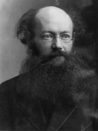
Peter Alexeivitch Kropotkin

Peter Alexeivitch Kropotkin

Summary

Portrait of Peter Alexeivitch Kropotkin Peter Alexeivitch Kropotkin 1911 Encyclopædia Britannica (1911)

The conception of north-west Mongolia as a region filled with mountain ranges radiating from the Altai must thus be abandoned. It is a massive swelling of the earth's crust, representing the northern counterpart of the plateau of Tibet. This massive swelling is cut into, between the Ektagh Altai and the eastern Tʽien-shan, by the relative depression of Tarbagatai and Dzungaria, 1500 to 3000 ft. in altitude; while to the south of the eastern Tʽien-shan comes the Tarim depression, from 2200 to 3000 ft. high, and occupying an area of about 88,000 sq.
Source: Wikisource

Portrait of Peter Alexeivitch Kropotkin Peter Alexeivitch Kropotkin 1911 Encyclopædia Britannica (1911)

In the winter the frozen river is the usual highway. Rough roads and bridle-paths only are found in the interior. The great engineering difficulties in building a railway along the Amur induced the Russian government to obtain from China permission to build a railway through Manchuria, but the project for a railway from Khabarovsk to Stryetensk received imperial sanction in the summer of 1906.
Source: Wikisource

Portrait of Peter Alexeivitch Kropotkin Peter Alexeivitch Kropotkin 1911 Encyclopædia Britannica (1911)

It is calculated that 100,000 camels are used for the transport of tea only from Kalgan to Siberia, and that no less than 1,200,000 camels and 300,000 ox-carts are employed in the internal caravan trade. Agriculture is only carried on sporadically, chiefly in the south, where the Mongols have been taught by the Chinese. Various domestic industries are also carried on. The trade is chiefly concentrated at Urga, Ulyasutai and Kobdo in north-west Mongolia; Kalgan, Kuku-khoto, Kuku-erghi, Dolon-nur and Biru-khoto in southern and south-eastern Mongolia
Source: Wikisource

Get perspective with Kwize: daily news enlightened by great literature