Summary

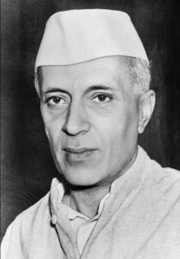
Portrait of Jawaharlal Nehru Jawaharlal Nehru Letter from the Prime Minister of India to the Prime Minister of China

I do hope that a study of the foregoing paragraphs will convince you that not only is the delineation of our frontier, as published in our maps, based on natural and geographical features but that it also coincides with tradition and over a large part is confirmed by international agreements. I need hardly add that independent India would be the last country to make any encroachments beyond its well -established frontiers.
Source: Wikisource

Portrait of Jawaharlal Nehru Jawaharlal Nehru Letter from the Prime Minister of India to the Prime Minister of China

Thus, in these three different sectors covering such the larger part of our boundary with China, there is sufficient authority based on geography, tradition as well as treaties for the boundary as shown in our published maps. The remaining sector from the tri-junction of the Nepal, India and Tibet boundary up to Ladakh is also traditional and follows well defined watersheds between the river systems in the south and the west on the one hand and north and east on the other.
Source: Wikisource

Get perspective with Kwize: daily news enlightened by great literature