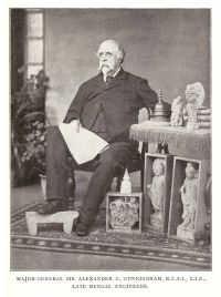
Alexander Cunningham

Alexander Cunningham

Summary

Portrait of Alexander Cunningham Alexander Cunningham The Ancient Geography of India (1871)

On the west, the course of the Indus from Ohind, above Attok, to the sea is 950 miles by land, or about 1200 miles by water. On the north, the distance from the banks of the Indus to Patna, by our military route books, is 1143 miles, or only 6 miles less than the measurement of the royal road from the Indus to Palibothra, as given by Strabo on the authority of Megasthenes. Beyond this, the distance was estimated by the voyages of vessels on the Ganges at 6000 stadia, or 689 British miles, which is only 9 miles in excess of the actual length of the river route.
Source: Wikisource

Portrait of Alexander Cunningham Alexander Cunningham The Ancient Geography of India (1871)

Alexander "caused the whole country to be described by men well acquainted with it;" and this account was afterwards lent to Patrokles by Xenokles, the treasurer of the Syrian kings. Patrokles himself held the government of the north-east satrapies of the Syrian empire under Seleukus Nikator and Antiochus Soter, and the information which he collected regarding India and the Eastern provinces, has received the approbation of Eratosthenes and Strabo for its accuracy.
Source: Wikisource

Get perspective with Kwize: daily news enlightened by great literature