Summary

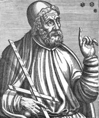
Portrait of Ptolemy Ptolemy Ancient India as Described by Ptolemy (1885)

India beyond the Ganges is bounded on the west by the river Ganges; on the north by the parts of Skythia and Sêrikê already described; on the east by the Sinai along the Meridian, which extends from the furthest limits of Sêrikê to the Great Gulf, and also by this gulf itself, on the south by the Indian Ocean and part of the Green Sea which stretches from the island of Menouthias in a line parallel to the equator, as far as the regions which lie opposite to the Great Gulf.
Source: Wikisource

Portrait of Ptolemy Ptolemy Ancient India as Described by Ptolemy (1885)

I have, as a rule? quoted the sources from which my information has been derived, but may here state that I have generally adopted the views of M. Vivien de Saint-Martin and those of Colonel Yule, whose map of ancient India in Smith's well- known historical Atlas of Ancient Geography is allowed on all hands to be the best that has yet been produced. These authors have examined the greater part of the Ptolemaic Greography of India, and their conclusions are for the most part coincident.
Source: Wikisource

Portrait of Ptolemy Ptolemy Ancient India as Described by Ptolemy (1885)

Ptolemy's object in composing it was not like that of the ordinary Geographer to describe places, but to correct and reform the map of the world in accordance with the increased knowledge which had been acquired of distant countries and with the improved state of science. He therefore limits his argument to an exposition of the geometrical principles on which Geography should be based, and to a determination of the position of places on the surface of the earth by their latitudes and longitudes.
Source: Wikisource

Get perspective with Kwize: daily news enlightened by great literature