Summary

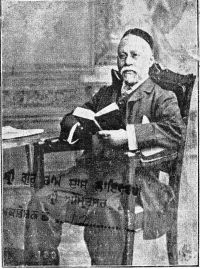
Portrait of Behramji Malabari Behramji Malabari Gujarát and the Gujarátis — end matter (1882)

It combines the usual features of a good plain map of the country on a scale of 150 miles to the inch, with a faithful representation of all the uneven surfaces, modelled on a scale thirty-two times the horizontal one; thus bringing out into clear relief the comparative heights and outlines of all the hill-ranges, and showing broad tracts of uneven ground, of intermingled hill and valley, which a common map of the same size would hardly indicate, except to a very practised eye. The plains of Upper India are reduced to their true proportions
Source: Wikisource

Portrait of Behramji Malabari Behramji Malabari Gujarát and the Gujarátis — end matter (1882)

To the historical as well as the geographical student such a map is an obvious and important aid in tracing the course of past campaigns, in realising the conditions under which successive races carried their arms or settlements through the Peninsula, and in comprehending the difference of race, climate and physical surroundings which make up our Indian Empire.
Source: Wikisource

Portrait of Behramji Malabari Behramji Malabari Gujarát and the Gujarátis — end matter (1882)

Comprising a Concise Grammar; Exercises and Dialogues; Familiar Phrases, Proverbs, and Vocabulary. By Major H. G. Raveett, Bombay Infantry (Retired) . Fcap. 5s.
A RELIEVO MAP OF INDIA.
By HENRY F. BRION.
In Frame, 21s.
"A map of this kind brings before us such a picture of the surface of agiven country as no ordinary map could ever do. To the mind's eye of the average Englishman. India consists of 'the plains' and 'the hills,' chiefly of the former, the hills being limited to the Himalayas and the Nilgiris. The new map will at least enable him to correct his notions of Indian geography.
Source: Wikisource

Get perspective with Kwize: daily news enlightened by great literature