Summary

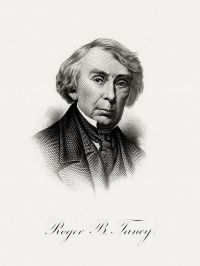
Portrait of Roger B. Taney Roger B. Taney Missouri v. Iowa (51 U.S. 1) — Opinion of the Court

Louis, we obtained from Major M. L. Clark, Surveyor-General of the States of Missouri and Illinois, a copy of the field notes of the survey made by John C. Sullivan, in the year 1816, of a line beginning on the east bank of the Missouri River, opposite the middle of the mouth of the Kansas River, and extending north one hundred miles, where he made a corner, and also of the line run by him in an easterly course to the Des Moines River.
Source: Wikisource

Portrait of Roger B. Taney Roger B. Taney Missouri v. Iowa (51 U.S. 1) — Opinion of the Court

But there are great irregularities in the course of the line, for which it is difficult to find a cause. Sudden deviations amounting to from one to three degrees frequently occur, and it rarely happens that any two consecutive miles pursue the same direction.
A resurvey of the line between the 91st and 134th miles was made in the year 1845, and we found the witness-trees on that part of the line defaced, and others substituted. We succeeded, however, in identifying Sullivan's trees, and we destroyed the marks of that survey as far as they related to the old line.
Source: Wikisource

Portrait of Roger B. Taney Roger B. Taney Missouri v. Iowa (51 U.S. 1) — Opinion of the Court

From the monument so planted at the 'northwest corner' aforesaid, in the said latitude, the survey of the line was commenced, running due west on said parallel of latitude to the Missouri River, as directed by this honorable court, and at its terminus, as near the bank of said Missouri River as the perishable nature of the soil would admit, we planted a monument similar in figure, weight, dimension, and inscription to the one planted at the 'northwest corner,' the words 'State Line' facing the east.
Source: Wikisource

Get perspective with Kwize: daily news enlightened by great literature